Introduction to the Marshall Islands Stick Maps
Westerners encounter Stick Charts (1862)
-
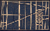
- Different examples of stick charts:
- mattang chart shows general patterns of waves around islands
- rebbelib shows islands and swells (another example)
- maddo local map with Kwajalein in center and herring bone shows changes caused by northeast trade winds around Jaluit Atoll.
The master account of Polynesian Navigation by the late Ben Finney
Beautiful pictures of the Marshall Islands; their Flowers
Zoom out to see where these islands are in the Pacific
View Marshall Islands in a larger map