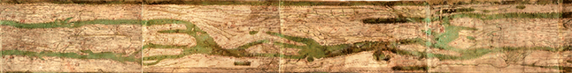
This website includes an interactive map with filterable overlays and magnification, allowing the user to examine the Peutinger Table in greater detail. , The site is extremely useful for making sense out of the map’s symbols and distorted proportions.
In order to appreciate a map illustrating Roman roads, you have to understand what a Roman road was and what it did. This website describes how Roman roads were designed, constructed, and maintained, as well as their benefits to the Roman Empire. In particular, the site focuses on the military value of an efficient road system.
This website shows the significance of Roman roads in carrying out trade with want to Asia, again illustrating Rome’s vast economic reach.
Want to travel the Roman Roads?
This unusual site provides an interactive modern day map with an overlay of all the locations on the Peutinger Table, allowing you to pick a section of the road to travel.
View Peutinger Table in a larger map